Some of the evidence compiled regarding the Great Grove Creek Crayfish Kill can be found below.
Pictured below is the area in question. Even from this altitude, much higher than that spray plane was flying at, the neighbors' large ponds and Grove Creek stand out.
 |
Terry Schabacker's fields where application was made
July 10, 2012
The following photo is from a lower altitude. Note the neighbor's
ponds again in the center of the previous photo for reference.
 |
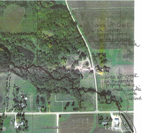
Photo shows Michael Hardesty's property, and the area
of Grove Creek where the crayfish were collected.
The pilot Stan most likely made an
approach at a lower altitude than this. How could this water be
missed?
This next image is from a higher altitude, and shows the route of
Grove Creek and some neighboring properties:
If you straighten the crooked line, you
will find it to be approximately 1/2 mile from the point of
contamination to where the first dead crayfish were discovered.
This next photo shows the area where the dead crayfish were
collected. The distance between the cornfield and the creek is
approximately 20-30 feet, at most. This is the cornfield where the
application took place.
 |
This is the area of the creek where David collected
dead crayfish.
The following photo is taken at ground level and at a distance, from even as low as 20', how could this be missed? Well, is wasn't, at least with Stan's lethal dose, that three-part cocktail.

The minimum drift line in 10.4 mph winds, with mist droplets airborn for only one minute, would bring the spray to the middle of the pond.
No comments:
Post a Comment